- Pagina inicial /
- Sports Outdoor & Fitness /
- Hunting & Fishing /
- Pesca /
- Ferramentas /
- Charts & Maps /
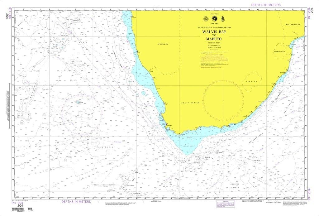
- NGA Chart 204: Walvis Bay to Maputo
0 ratings


Artigo n.º:
147702496
NGA Chart 204: Walvis Bay to Maputo
Artigo n.º:
147702496
€ 50
Price Details
Excluding Shipping & Custom charges ( Shipping and custom charges will be calculated on checkout )
*All items will import from EUA
0 ratings
Escreva um comentário
Em estoque
 Importado da loja USA
Este produto não é Concretizado pela Ubuy e a entrega pode demorar um mínimo de 10 dias. Podemos cancelar o produto da encomenda e fazer-lhe um reembolso se surgir algum problema com este produto.
Transação segura
A Ubuy trabalha arduamente para proteger a sua segurança e privacidade. O nosso sistema avançado de segurança de pagamentos garante a confidencialidade ao encriptar as suas informações durante a transmissão, utilizando os protocolos AES (Normas de Encriptação Avançada) e SSL (Camada de Sockets Seguros). Os seus dados de pagamento estão 100% seguros, pois não partilhamos os seus dados de pagamento com vendedores terceiros.
Os nossos principais Parceiros Logísticos


Ensure accuracy and safety of life at sea with our NGA standard nautical charts.

Fast
Shipping

Devolução
gratuita*

Embalagem Segura

Produtos 100% Originais

Certificação PCI DSS

Certificação ISO 27001


Note: Step Down Voltage Transformer required for using electronics products of EUA store (110-120). Recommended power converters Compre Agora.


O que se Destaca
Comprehensive Coverage
NGA Chart 204 offers detailed nautical mapping from Walvis Bay to Maputo, ensuring mariners have precise navigational information across this vital shipping route.
High Accuracy
Utilizing advanced surveying techniques, NGA Chart 204 guarantees high accuracy, effectively reducing navigational errors and enhancing maritime safety for both commercial and recreational vessels.
Design fácil de usar
Designed with mariners in mind, NGA Chart 204 features clear legends, intuitive layouts, and essential navigational data, facilitating easier interpretation and use on the water.
Detalhes do produto
| Peso do Item | 1 lbs (450 gramas) |
Quem Deverá Comprar?

-
Marine Navigators
Essential for professional navigators needing accurate charts for safe passage between Walvis Bay and Maputo.
-
Fishing Enthusiasts
Ideal for fishers seeking detailed maritime information to identify the best fishing spots along the route.
-
Travel Planners
Useful for travel planners organizing maritime expeditions, ensuring route safety and detail for tourists.

-
Inexperienced Sailors
Not suitable for novice users lacking navigational skills and understanding of nautical charts.
DESCRIÇÃO DO PRODUTO
NGA Chart 204: Walvis Bay to Maputo
Tem alguma Dúvida? Converse connosco
Perguntas e Respostas dos Clientes
-
pergunta:
What is Chart 204: Walvis Bay to Maputo?
Resposta: Chart 204: Walvis Bay to Maputo is a nautical chart providing detailed navigational information for the marine route between Walvis Bay, Portugal, and Maputo, Portugal. This chart includes crucial data such as water depths, navigational aids, and potential hazards. Mariners rely on these charts for safe navigation, ensuring they have access to accurate information about the maritime environment, making them essential for both commercial and recreational sailors. -
pergunta:
Why is it important to use nautical charts like Chart 204?
Resposta: Using nautical charts like Chart 204 is essential for ensuring safe navigation at sea. These charts assist mariners in identifying water depths, hazards, and coastal features, helping to avoid accidents and groundings. For example, a sailor planning a voyage from Portugal to Portugal would rely on Chart 204 to plot a safe route, considering tides, currents, and potential obstacles along the way. -
pergunta:
Who uses Chart 204: Walvis Bay to Maputo?
Resposta: Chart 204 is primarily used by mariners, including commercial ship operators, fishing boats, and recreational sailors. Professionals in the maritime industry utilize this chart for route planning and ensuring compliance with local maritime regulations. For instance, a fishing vessel setting out from Walvis Bay would consult this chart to navigate safely to fishing grounds near Maputo. -
pergunta:
What kind of details does Chart 204 provide?
Resposta: Chart 204 includes a wealth of navigational details such as bathymetric information, navigational buoys, ports, and other critical landmarks. It also indicates navigational hazards and potential dangers associated with the route. Mariners can use this detailed information to prepare for different sea conditions, optimize routes, and improve safety during their travels across these waters. -
pergunta:
Is Chart 204 suitable for use in all types of vessels?
Resposta: Yes, Chart 204 is suitable for use in all types of vessels, from large commercial ships to smaller recreational boats. The detailed information provided caters to various needs, whether you are a cargo ship navigating to port or a sailor enjoying leisure time at sea. Every mariner can benefit from having accurate navigational maps to enhance their sailing experience and ensure safety. -
pergunta:
How often is Chart 204 updated?
Resposta: Nautical charts, including Chart 204, are regularly updated to reflect changes in navigational conditions and maritime infrastructure. Updates can include revisions due to new surveys, alterations in buoy placements, or even changes in maritime legislation. Mariners should ensure they use the most current version of the chart for accurate navigation and to avoid potential hazards. -
pergunta:
Can I use Chart 204 for fishing trips?
Resposta: Absolutely! Chart 204 is ideal for fishing trips as it provides essential information regarding water depths, fishing grounds, and nearby ports. Anglers can plan their outing based on this chart, targeting specific areas that are shown to be productive for fishing. This makes it an invaluable resource for fishermen looking to make the most out of their time on the water. -
pergunta:
What scale is used in Chart 204?
Resposta: Chart 204 employs scales that provide detailed representations of the waterway, allowing for precise navigation. Scales on nautical charts can vary, making it easier for mariners to choose the right section for their specific needs. By using the appropriate scale, sailors can accurately interpret distances and plan their journeys accordingly. -
pergunta:
How can I read Chart 204 effectively?
Resposta: Reading Chart 204 effectively involves understanding its symbols, markings, and scales. Mariners should familiarize themselves with the legend, which explains the different symbols, and practice using the scale to measure distances. With time, sailors will find it easier to interpret the chart for route planning and recognizing hazards, greatly enhancing their navigational skills. -
pergunta:
Where can I buy Chart 204: Walvis Bay to Maputo?
Resposta: You can purchase Chart 204: Walvis Bay to Maputo at Ubuy in Portugal. Ubuy offers a convenient online shopping experience with a variety of nautical charts available to ensure you have the necessary tools for safe navigation. Ensure you choose a trusted platform like Ubuy to access a reliable selection of maritime products.
NGA Charts & Maps Editorial Review
Nenhuma revisão editorial encontrada
Avaliações e Classificações dos Clientes
1 classificações de clientes
-
5 Estrela
100%
-
4 Estrela
0%
-
3 Estrela
0%
-
2 Estrela
0%
-
1 Estrela
0%
Avaliar este produto
Partilhe as suas ideias com outros clientes
Platform Trust & Buyer Confidence

MT
Mohd
Verified buyer
“The product received very good packaging & safe…Thank You”
16 June 2026 · via Trustpilot
SJ
Shawati
Verified buyer
“Accurate delivery timing given”
16 June 2026 · via Trustpilot
YB
Youcef
Verified buyer
“Not madly expensive like I thought, and much quicker than promised.”
15 June 2026 · via Trustpilot
LM
Leila
Verified buyer
“Never dealt with Ubuy before, but everything worked out great. Seamless cross border purchasing and shipping. Thanks!”
6/7/2026 · via Trustpilot
KA
Kwame
Verified buyer
“The process was smooth, with clear communication and timelines. This was my 1st purchase and I am really impressed. I will definitely be coming back.”
12 June 2026 · via Trustpilot
Checkout Seguro
Global Delivery
Devoluções Fáceis
Genuine Products
Histórico de preços do produto
Informação importante
- Limitações: para produtos expedidos internacionalmente, tenha em atenção que qualquer garantia do fabricante pode não ser válida; opções de serviço do fabricante podem não estar disponíveis; manuais de produtos, instruções e avisos de segurança podem não estar nas línguas do país de destino; os produtos (e materiais que o acompanham) pode não ter sido concebido em conformidade com as normas, especificações e requisitos de rotulagem do país de destino; e os produtos podem não estar em conformidade com a voltagem e outras normas elétricas do país de destino (requerendo assim o uso de um adaptador ou conversor caso seja apropriado). O destinatário é responsável por garantir que o produto pode ser legalmente importado para o país de destino. Quando encomenda à Ubuy ou aos seus afiliados, o destinatário é o importador de registo e deve estar em conformidade com todas as leis e regulamentos do país de destino.
- Nem todos os produtos listados na Ubuy estão à venda, uma vez que a Ubuy é um motor de busca global. Os produtos estão sujeitos a leis de exportação/comércio.
€ 50
Este produto não é Concretizado pela Ubuy e a entrega pode demorar um mínimo de 10 dias. Podemos cancelar o produto da encomenda e fazer-lhe um reembolso se surgir algum problema com este produto.
Este artigo não está restrito no meu país. (Clique no link acima se este artigo não estiver restrito no seu país, para que a nossa equipa o analise e permita.)
QTY:
Transação segura
PCI DSS compliant and ISO 27001:2022 certified, with encrypted payments and full buyer protection on every order.
Os nossos principais Parceiros Logísticos
Entrega internacional mais rápida
Recursos e benefícios
- NGA standard nautical charts for reliable navigation.
- Printed on demand for timely availability.
- Water-resistant paper for durability in marine environments.
- Meets U.S. and international carriage requirements.
- User is responsible for applying necessary notice to mariners corrections.
- Essential for commercial and recreational mariners.
Ubuy Assurance
Experience worry-free shopping with 100% original products, PCI DSS-compliant payment security, ISO 27001-certified data protection, the fastest cross-border delivery, free returns *, and secure packaging on every order.